Dr Kathleen Kozyniak
Principal Scientist Air
Hawke’s Bay Regional Council
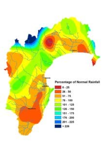
After a sodden June, it was nice to have reasonably settled weather in July. The region’s rainfall hit 82% of the July average, which meant it edged into what’s considered the normal range. i.e. between 80 and 120% of the month’s average rainfall. But it wasn’t divvied up fairly. Rainfall was well below normal on the Ruataniwha Plains, just 58% of average July rainfall, followed by the south coast on 66% and the Heretaunga Plains on 70%. Areas north of Napier did quite a bit better, particularly Tangoio. One consolation for Central Hawke’s Bay is that the headwaters of the area’s rivers benefited from near average rainfall in the Ruahine Ranges.
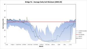
A run of drier weather towards the end of July didn’t see soil moisture drop greatly. Levels around the region appeared to be at or near we would expect them to be two-thirds of the way through winter. Soil temperatures ended July near 10°C in lowland areas and about 6°C in the ranges. That’s a smidgen above average. Air temperatures through July were very close to average, both the daytime maximum and night time minimum. A fairly typical July all up.
A number of different organisations have models producing three month seasonal outlooks and it helps when they align and tell a consistent story. Not so for August to October unfortunately. Some have higher than normal sea level pressure over northern New Zealand and others to the south of the country. For the most part they suggest near normal rainfall and near or above average temperatures for the period. Easterly winds may come to the fore in September and October and that onshore direction raises the chance of getting some wet weather. Easterlies are characteristic of La Niña events and it remains a roughly 50:50 chance that we’ll get a weak La Niña for the spring and summer.

July 2020 Rain Map


