Dr Kathleen Kozyniak
Principal Scientist Air
Hawke’s Bay Regional Council
June rainfall exceeded expectations and put any suggestion of a potentially drier than normal winter on very shaky ground. The region received roughly double the month’s long term average, breaking the drought that has plagued us since last November. July has had a cautious start and after the first week we range from 20% of average July rainfall in the region’s north to 5% on the Heretaunga and Ruataniwha Plains.
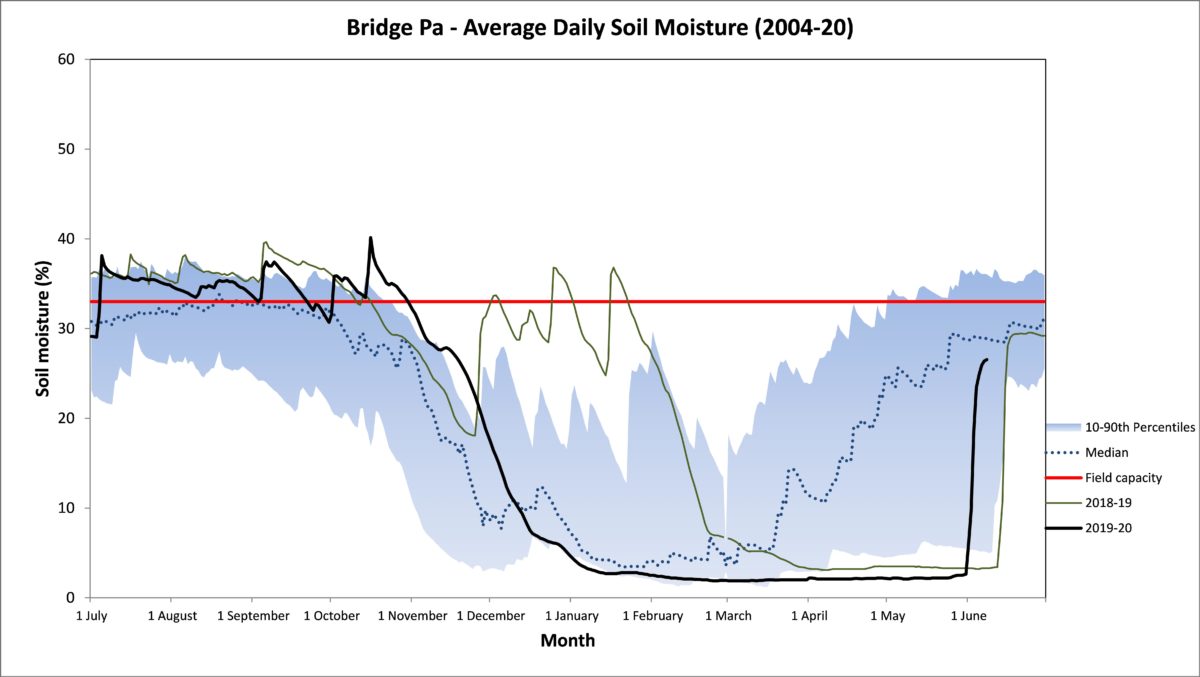
Soil moisture levels have recovered well and typically sit at or above median levels for the time of year. The levels at our Bridge Pa site even managed to sneak into the top 10th percentile of readings at the end of June. Quite a turnaround from record lows leading into the month. June’s air temperatures were 1-2°C above average, with the night-time temperatures particularly warm due to grim but welcome weather, narrowing the diurnal temperature range – only a few degrees on a number of days. That kept June’s soil temperatures above average and mostly in double digits, which hopefully meant some growth for plants that were previously water limited.
The prospects ahead are mixed. Metservice has a forecast for normal or below normal rainfall for July. NIWA is picking normal or above normal rainfall for the July to September period and above average temperatures. The seasonal forecast models suggest higher than normal sea level pressure to the north and southwest of us. That would favour westerly winds and potentially drier conditions, with the odd icy blast coming from the south. However both NIWA and the Australian Bureau of Meteorology are on “La Niña watch” for our spring and summer and it’s 50:50 whether it will develop or we’ll remain in neutral mode. A developing La Niña might mean we start to get more easterlies than anticipated, as we did during June, which would bring an increased likelihood of near normal rainfall.

June 2020 Rain Map

Dr Kathleen Kozyniak
Principal Scientist Air
Hawke’s Bay Regional Council
It was great to have some rain to kick off winter but it comes off seven consecutive months, i.e. November to May inclusive, of below normal rainfall for some parts of our region, namely the Heretaunga and Ruataniwha Plains and the Ruahine Range. The rest of the region has had low rainfall for five or six of the seven months.
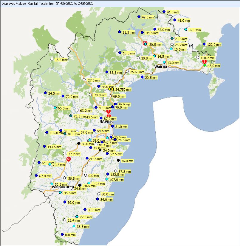
Soil moisture levels have been at record lows throughout May on the Plains and the surrounding hill country and only in the far north of the region have we hit median levels for the time of year. Queen’s Birthday Monday saw 30-60 mm of much needed rain on the Plains and over 100 mm in the ranges. As a result, soil moisture levels have risen out of the lowest 10th percentile of measurements, for now at least. The Heretaunga and Ruataniwha Plains have had 60% of June rainfall already while northern Hawke’s Bay has had only 20-25%. Soil temperatures are around 12°C, which is warm for the time of year, though they are likely to cool by the end of the week.
The rain is especially welcome as the seasonal forecast models suggest we may get normal or below normal rainfall for the three months ahead. It’s due to higher than normal pressures over northern New Zealand with models favouring a westerly flow. They paint a picture of a potentially wetter western side of the country and a normal or dry east and temperatures near or above normal. The El Nino-Southern Oscillation should stay neutral through winter. Neutral or La Niña conditions appear to battle for supremacy through spring, while El Niño conditions have the lowest probability of eventuating. A negative or neutral Indian Ocean Dipole (IOD) seems likely for spring too, which is hopeful. A positive IOD, such as last year, tends to bring us a drier spring and early summer weather.
Queen’s Birthday 2020 Rainfall Accumulation