
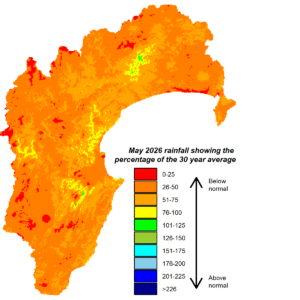
The promised El Niño event is here and May’s rainfall could be the sorry theme in the months ahead. The region’s May total was well below normal, only 34%, while the Heretaunga Plains, Ruataniwha Plains and Ruahine Range had a lowly 18-20%. River flows were below average but groundwater levels were normal as April’s more ample rain filtered through. Air temperatures were near average, so too soil moisture. Sea temperatures around New Zealand have been above average.
El Niño conditions mean west to southwest winds will feature strongly in the months ahead and the predicted sea level pressure pattern reflects this. Higher than normal pressure extends across Australia and much of New Zealand. Lower than average pressure is expected to lie south of the country and to the northeast. The outlook for rain isn’t rosy due to our western ranges blocking a lot of the westerly rain. June rainfall totals so far haven’t been great, though rain is likely during the last week of the month. The July to September forecasts paint a picture of drier weather and temperatures near average. Indications are that it will be a strong El Niño event and accompanied by a positive Indian Ocean Dipole in spring. While these events can be unique in their impacts on the region, together they don’t signal good prospects of rain over spring and summer.


