

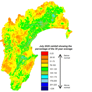
July wasn’t particularly kind to Hawke’s Bay, with the region receiving below average rainfall for the month. The Heretaunga Plains is the one area in Hawke’s Bay that has experienced three consecutive months of below normal rainfall. However, the good news is that river flows were near normal for July and similarly groundwater levels. Soil moisture held up well during the month and has since been boosted by early August rain. We had some balmy days during July, which tipped daytime averages for the month above average but night-time temperatures were colder than average. Sea temperatures in Hawke Bay were a little cooler than usual.
An El Niño event has roared into being during winter and is expected to extend through spring, summer and into next autumn. It’s already being categorised as a strong event and is expected to intensify further over spring to become a very strong event. A positive Indian Ocean Dipole is predicted to sit alongside it in spring, as it can often do. Both can mean reduced rainfall for the region by enhancing westerly winds over New Zealand and altering storm tracks.
Each El Niño event can play out differently, so drier than usual seasons ahead may not be the outcome, but having a plan in case it does is a good idea. Current predictions suggest spring will have a drier than average theme. This comes from westerly winds featuring during the season from a pattern of above normal sea level pressure west of New Zealand and below normal pressure to the east of the country. Spring temperatures could average out to near normal with a continued swing between balmy days and days that feel more like a lingering winter. As this El Niño
event intensifies further, it will be worth keeping track of how it impacts the region’s water resources.


