
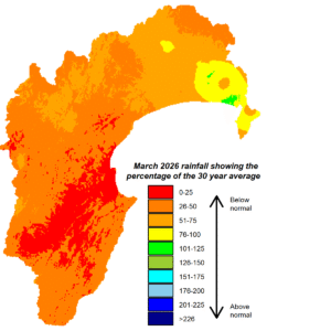
After a wet summer, much drier weather kicked off autumn. March rainfall was well below normal, with the region getting just 38% of the month’s average and the Heretaunga Plains a mere 14%. River flows were well below average and soil moisture, which was high during summer, pared back to sit near median levels for the time of year. Groundwater levels remained in good heart at the time of measuring. Air temperatures were average for early autumn so didn’t accelerate dry conditions with super-hot days.
The tropical cyclone season runs until the end of April and that tropical influence, helped by warmer than average seas around New Zealand, has already left April’s rainfall looking healthy. With an El Niño event expected to develop by spring this year, good moisture stores leading into it would be ideal! Seasonal forecast models already indicate drier conditions are on the horizon. Over the next three months, their predicted sea-level pressure pattern is higher than average pressure west of New Zealand, near normal pressure over the country and lower than average pressure to the east. That gives the region a west to southwest flow, bringing into play the rain shadow effect of our western ranges. Near or below normal rainfall is their favoured outcome and near normal temperatures. We’ll be keeping a wary eye on the looming El Niño.


