Dr Kathleen Kozyniak
Principal Scientist Air
Hawke’s Bay Regional Council
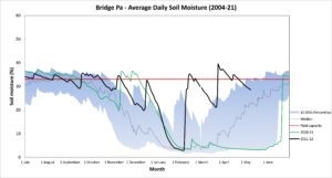
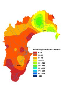
April brought some respite from the copious amount of rain we received in the previous two months. Northern Hawke’s Bay got close to normal April rainfall but the rest of the region received only about a third of April’s average total. Soil moisture remains high, despite the paucity of rain, and sits above median levels for the time of year. Groundwater levels are likewise biased higher than usual and river flows are the same. As we head into the cooler months, it takes longer for us to shed the excess water in the environment, so the drier April weather brought only a gradual decline in water stocks. Mind you, April’s air temperatures and soil temperatures were warmer than average, with the latter ending the month at 14°C on the Plains and 11°C in the ranges.
The La Niña is clinging on and still influences our weather. It’s likely to weaken but bets favour it returning in summer, while the chances of a summer El Niño seem remote. Over the next few months we have a weather pattern that hasn’t budged much so far this year. Sea level pressures are expected to be higher than normal to the east of the country and lower to the northwest, so easterly winds will remain prevalent.
One notable change is that seasonal forecast models are much more mixed in their rainfall predictions. There is quite a range of above normal to below normal forecasts, whereas in previous months they were stoic in picking near or above normal totals. Sea temperatures around Hawke’s Bay are closer to normal and anticyclones may be fairly prevalent in the next few months, together taking the edge off the rain factory we had in February and March and steering temperatures to near normal or above normal range. We might see winter introduced in what could be thought of as fairly typical fashion.


