Excessive amounts of rain came back to haunt us in June. We had 250% of the month’s long-term average rainfall and river flows were above normal by a similar percentage. The wet June broke a run of three months of below normal rainfall that both the Heretaunga Plains and northern Hawke’s Bay got to enjoy.
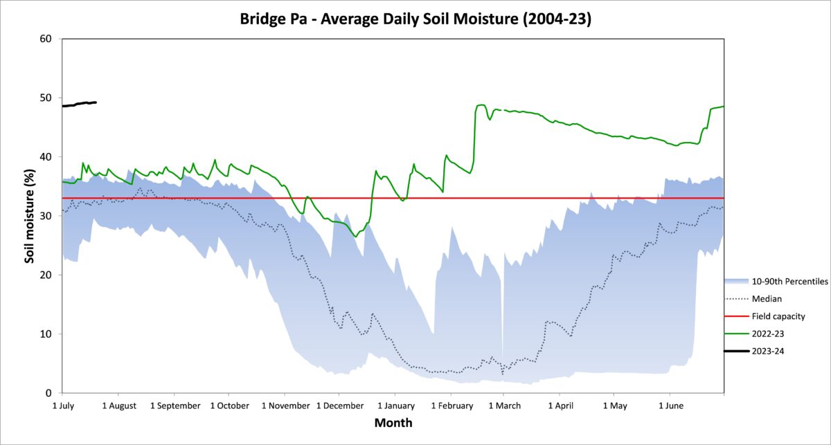
Soil moisture had been trying to dry out before June’s rain scuppered the effort. Groundwater levels in June pulled back from the very high levels seen through the first part of the year but they were yet to reflect the month’s rainfall. Air temperatures were warm for the time of year, especially the nights, which were more than 2°C above average for June. No surprises then that soil temperatures were also above average. The extra warmth was fired by warmer than usual seas around Hawke’s Bay.
Looking ahead, the expectation remains that an El Niño will bed in and a positive Indian Ocean Dipole will develop in late winter or spring. Westerlies are likely to feature over the next three months due to the forecasted sea level pressure pattern, being higher than normal pressure extending across Australia and north of New Zealand, and lower pressure to the south. However don’t discount the odd bout of easterly winds as the transition to an El Niño regime continues. Ongoing warmer than normal seas will help to keep temperatures near or above average but they might confuse matters with respect to rainfall. Drier weather is more commonly linked to colder seas. Near or below average rainfall is predicted for the coming three month period but the current warm seas may slow the move to drier weather.
.
.
Percentage of Normal Rainfall


Dr Kathleen Kozyniak
Principal Scientist Air
Hawke’s Bay Regional Council


