Dr Kathleen Kozyniak
Principal Scientist Air
Hawke’s Bay Regional Council
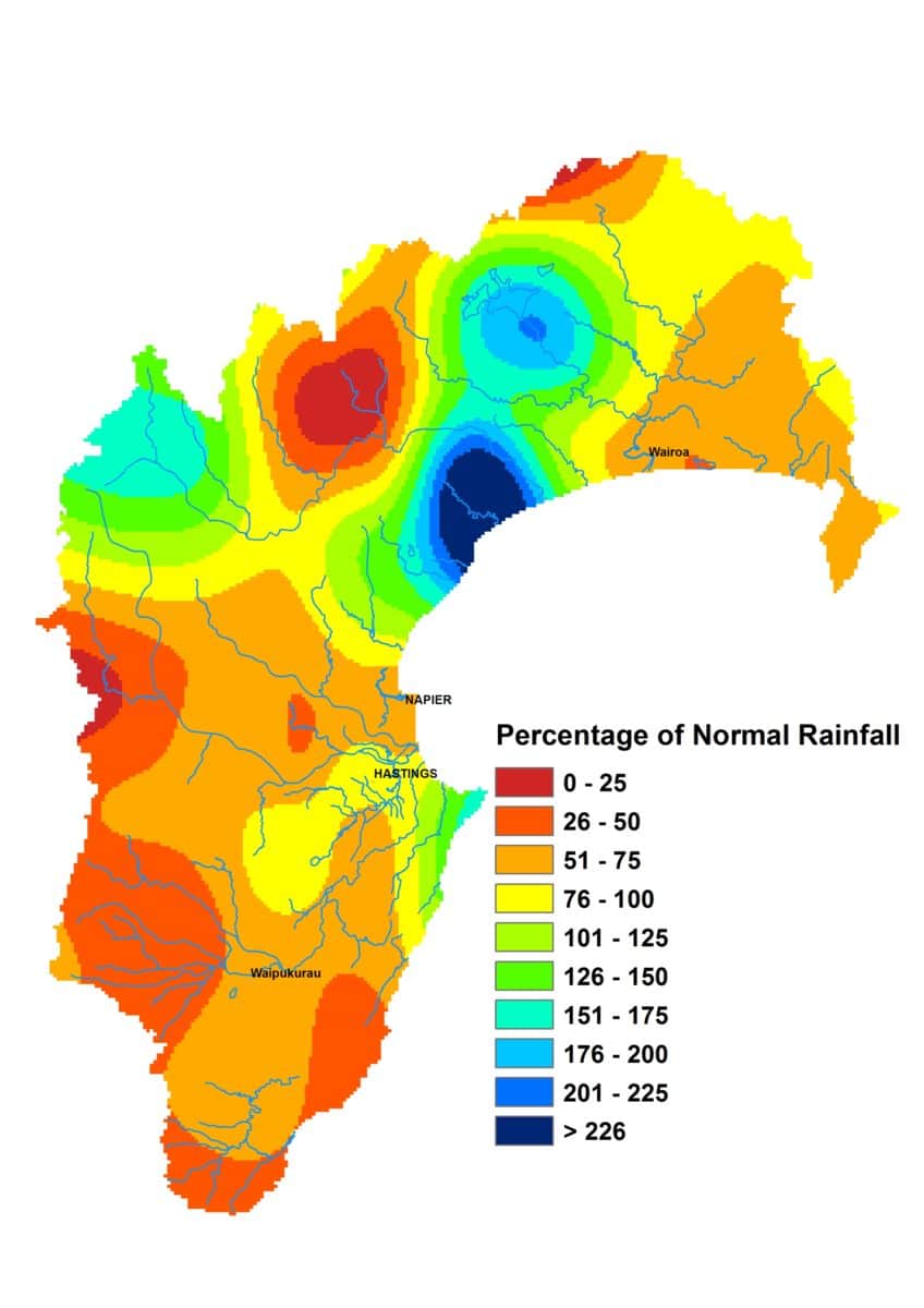
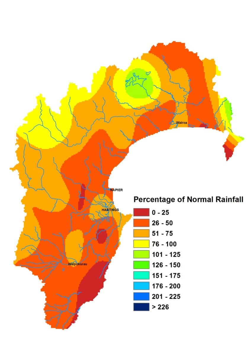
February brought good news for the northern parts of our region, where rainfall totals were near average for the month. Things weren’t so rosy for the rest of Hawke’s Bay. The Heretaunga Plains received only 72% of average February rainfall and the Ruataniwha Plains only 52%, while rainfall in the Kaweka and Ruahine ranges, where the headwaters of some of our main rivers lie, reached 59% and 46%. All of those areas have now had three consecutive months of below normal rainfall. That’s not great.
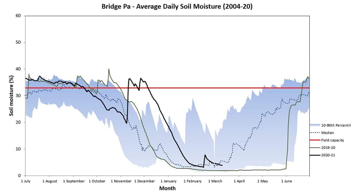
The low rainfall resulted in river flows being lower than average across the region and put soil moisture on a track heading below median levels for the time of year on the Plains as well as (and even more so) in the hill country west of Hastings. Groundwater levels, thankfully, were okay for the end of summer compared to average and November’s rainfall proved a good fillip for our groundwater stocks. February temperatures weren’t overly hot and soil temperatures started March in the early twenties on the Heretaunga and Ruataniwha Plains.
As I write this, rain is falling (terrific!) and Metservice severe weather watches and warnings are in place. Hopefully over the next 24 to 48 hours we’ll get a good dose of steady rain to bolster soil moisture and get those rivers flowing. The La Niña event that’s been with us through summer is expected to wane through autumn and neutral conditions come to the fore. The seasonal forecast models continue with a similar pattern of weather for autumn as they’ve had for summer – higher pressures to the south and southeast of us, lower to the northwest and generally a northeast wind flow. Normal rainfall for Hawke’s Bay is on the cards in their view, though chances are higher than normal totals might eventuate in the north and lower totals in the south. Hopefully not the latter. Temperatures should be near or above normal.
Percentage of Normal Rainfall
John Wilton
This year, the Royal Gala group, the first of our main varieties will commence harvest around the second week in the month. As far as we can estimate Royal Gala harvest is expected to be about a week earlier than usual due to the particularly warm temperature we experienced immediately after blossom. From the middle of February Royal Gala group harvest will be in full swing. Use starch iodine to monitor maturity progression.
It is quite common for upper tree fruit to have the best colour, but lag behind lower tree in maturity, particularly in younger blocks, so it may not be necessary to use ladders for the first pick. This should speed up harvest if you do not need to worry about the upper tree in the first week.
Low colour, late pick Royal Gala is poor quality and needs to be left behind. Pick the eyes out of the crop, then move rapidly on to the next variety or later harvest blocks.
Where there is labour available, there is still time to revisit later varieties for further crop grooming. Attention to fruit light exposure is important for good colour development. Judicious, carefully supervised summer pruning and leaf plucking can make a big difference to pack out in red varieties.
Where branches have been allowed to lodge on lower branches due to fruit weight, tying these branches up with biodegradable string will often give a good return for effort.
Keep on top of the harvest. Fruit picked early in the harvest period for a variety is higher quality than later picked fruit and usually packs out better due to less handling injury than riper later picked fruit.
Labour is a problem this year. To get the best out of your workers, strong emphasis needs to be placed on training and supervision. Also think of smart ways to maintain morale and performance.
Dr Kathleen Kozyniak
Principal Scientist Air
Hawke’s Bay Regional Council
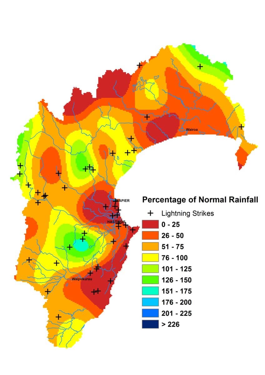
The past two months haven’t quite gone to the La Niña plan. January rainfall was below normal, roughly 57% of the long-term average. It follows a dry December for all except northern Hawke’s Bay. Two months of below normal rainfall has cut river flows off at the knees and low flows are proliferating. We’re steadily eroding the buffer that November gave us.
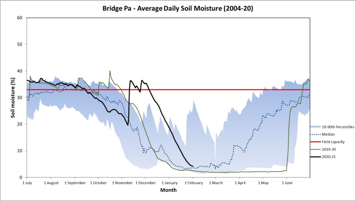
Groundwater levels ended December measuring mostly near or above normal – a terrific result that seemed a long time coming. Come the end of January and the below normal portion put up more of a fight. Soil moisture levels sat above or on median levels for January on the Heretaunga and Ruataniwha Plains but dipped below median levels at Crownthorpe and other parts of the region.
The top January temperature surpassed 35°C and overall the daytime temperatures were a good 1°C above average – great for those in holiday mode. Soil temperatures on the Plains spent the month in the mid to low twenties.
The La Niña continues, though a transition to neutral conditions is expected through autumn. It’s fair to scoff at previous promises of La Niña rain based on the results of the past two months. The forecast models aren’t so unanimous in that promise this time around. While they stick with the general pattern of weather they’ve depicted in the past few months, they aren’t necessarily equating it with high rainfall. Higher than normal sea level pressures to the south of the country, lower than normal to the northwest and associated easterlies remains in their forecasts. But it’s reasonable to expect an unchanged weather pattern to give an unchanged result, i.e. not as much rain as we’d like.
Potential still lies in a tropical cyclone outlook that suggests we could see an ex-tropical cyclone come our way by the end of April. Plus cyclone activity lingers about the Pacific Islands during the first half of February, the remnants of which we hope come our way.
Percentage of Normal Rainfall
John Wilton
The 2021 harvest will be very challenging in regard to labour. There is a lot of misinformation circulating in regard to pay rates and working conditions. This needs to be countered with the facts.
With good organisation, appropriate training and clear instructions, anyone who is reasonably fit and well motivated can earn good wages from fruit picking. Think of smart ways to motivate and retain harvest labour.
Make sure you have back up staff for critical jobs such as tractor drivers and forklift operators to make sure these people do not work excessive hours.
Pickers need clear instruction on what fruit to harvest when selective picking. Good picker training is necessary and needs to cover the many tricks of the trade that high performing pickers implement.
Understand the value of the fruit to be harvested and be prepared to bypass low value fruit if there is high value fruit ready for harvest.
Try to keep up with fruit maturity progression. The best fruit that is easiest to handle is that harvested in the first week of the harvest window. Regular maturity testing commencing three to four weeks ahead of expected harvest date is critical to identify maturity progression.
Heat units accumulated over the first 42 days after full bloom correlate strongly with the length of time from full bloom to harvest. This spring the heat units over that period were 40% above normal. This means that harvest will be earlier than normal by maybe a couple of weeks.
Early season Summerfruit appear to be running about two weeks ahead of normal.
Wishing you all a Merry Christmas and prosperous New Year.
Dr Kathleen Kozyniak
Principal Scientist Air
Hawke’s Bay Regional Council
The deluge in Napier and other parts of the region on the 9th November was enough to cast shade on the month’s average rainfall totals but that was then followed by frequent rain over the rest of the month. The final November tallies across the region were well above normal. The Heretaunga Plains and the region’s south coast received three times their average November rainfall, while most other areas were close to double their average. The Ruahine Range was one pocket where the comparison was modest, at 127%.
We’ve struggled with below average river flows for a number of months but finally we’ve turned a corner it seems. In November they were near normal around northern Hawke’s Bay and rachet up as you head south. In the Ngaruroro River we saw double the long term mean and, would you believe, a mighty 700% of the long term mean at a Wallingford site in the south.
Another worry has been groundwater levels that have persisted through the year at low levels. The latest measurements we have – and these were taken just prior to the 9th of November – show the majority of sites at near normal levels for the time of year on the Heretaunga and Ruataniwha Plains. That can only get better after November’s rain. Prolific rain has meant that soil moisture levels have spent much of the month around field capacity and a little dry spell wouldn’t actually hurt! Temperatures followed suit and were also above average – daily minimums by more than 1°C.
As the La Niña event continues and sea temperatures remain warmer than usual around the country, the seasonal forecast models are unanimous in depicting near or above normal rainfall for us during summer, plus warmer than usual temperatures. The wind flow is expected to be predominantly north-easterly due to higher than normal sea level pressures over southern New Zealand and to the east of our region and lower than normal to the northwest. Metservice predict below normal rainfall for December, based on a bout of westerlies to start the month and anticyclones to follow, but the overall picture for summer otherwise appears promising for rain.
John Wilton
We have seen some spectacular chemical thinning results this year, undoubtedly helped by the dull cloudy weather and warm nights.
With lower value commodity varieties such as the Royal Gala group where fruit drop has been good, these varieties will probably get through to harvest without much need for hand thinning. These are now low margin varieties so it is doubtful they could stand the cost of hand thinning which in larger old trees is probably close to $1 per carton.
Focus your hand thinning efforts on higher value varieties where there are good rewards for crop grooming. Thinning the ends of branches and the tops of leaders where large clumps of fruit often set is expensive and labour intensive. Most of this fruit is concentrated in the last 15 to 20cm of the leader or branch so a quick fix is to shorten the leader or branch by about 15cm. In the case of leaders in younger trees this shortening will stiffen the leader, as well as drive some very useable weaker side laterals.
Many newer blocks in Hawke’s Bay have been planted too close for the strength of the soil so it does not take long for fruiting laterals to become excessively strong for their allotted space. Excessive strong annual shoots will respond to heading back during December. We have also noticed that where annual lateral vigour is excessive there is a tendency for significant areas of bare wood back towards the leader. Shortening stronger laterals in December will avoid much of this problem and lead to a more efficient fruiting canopy.
John Wilton
For both Metamitron and the benzyladenine thinners sufficient water is necessary to give adequate spray covers, particularly in the upper tree. In our Metamitron development work, we standardised on 1 litre on spray to 10 cubic metres of tree row volume. This means that a full canopy intensive orchard in Hawke’s Bay requires somewhere between 1,200 and 2,000L/ha of spray. Recent experience with the BA thinners is also pointing towards higher water rates for full canopies.
It has come to our notice that many spray rigs are calibrated to apply 1,000L/ha which is insufficient wetting for good post blossom thinner response. This probably explains the disappointing thinning responses we often see.
Two or three thinning sprays at the most are applied, not the 20 to 24 general cover sprays so taking a bit more time to apply critical thinning sprays is not that onerous.
Sprayers should be equipped with flow meters so by altering speed of travel and pressures, it should be relatively simple to lift water rates into the optimum range for these thinning sprays. About 70% of the spray volume should be directed to the upper third of the canopy and about 70% of the total canopy sprayed for satisfactory results. Drip and drift should give sufficient wetting of the lower 30% of the canopy for good response.
Tree size variation has been a problem with thinning sprays leading to over spraying areas of smaller trees. Where there is variable tree size, speeding up where trees are small will reduce risk of over spray. A half size tree will only need about 1,000L/ha. Canopy density increases as the season advances so thinning sprays later in the window may require more water to allow for higher foliage area.
Dr Kathleen Kozyniak
Principal Scientist Air
Hawke’s Bay Regional Council
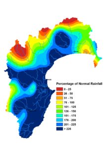
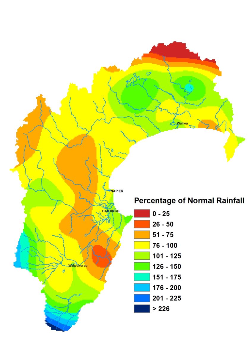
The region gets an A grade for hitting 100% of September’s average rainfall. It was on the back of overachievers like the north and south of the region and also the Ruahine Ranges, where rainfall exceeded the month’s average, whereas the Heretaunga Plains on 78% and Tangoio on 73% were slackers in comparison. It was a result full of promise for our groundwater, soil moisture and river flows – largely unfulfilled sadly.
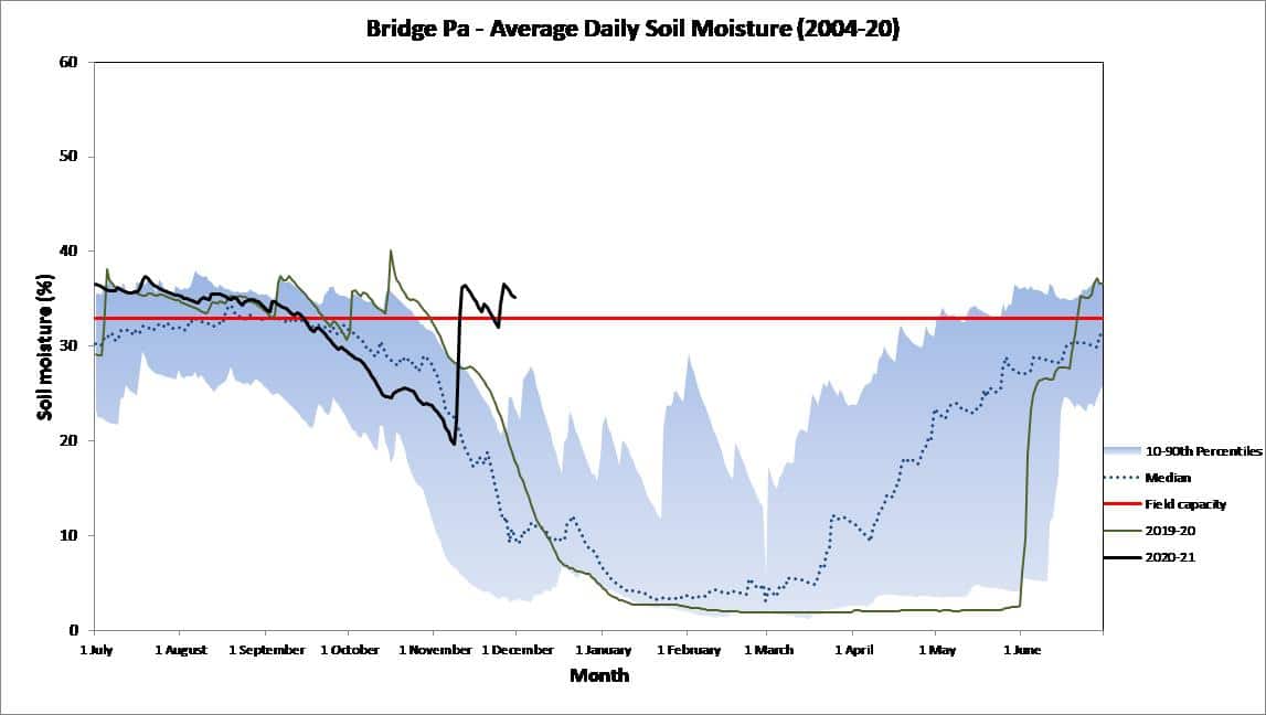
Groundwater levels can’t seem to shake their below normal malaise and river flows averaged a paltry 56% of typical September levels. It’s because soils were tight fisted with whatever water they got. Not so tight fisted that warm temperatures, egged on by bothersome westerlies, couldn’t wheedle out some of that moisture and leave soil moisture levels tracking on the wrong side of normal, particularly in Central Hawke’s Bay.
Prospects of rain are encouraging now that a La Niña is upon us and the Indian Ocean Dipole toys with turning negative. Higher than normal sea level pressures are forecast to the southeast of us and lower pressures to the northwest, which should set up an easterly flow that will hopefully be moisture laden from higher than normal sea temperatures. Rainfall should be near normal, if not above normal, in northern areas according to the seasonal forecast models. Most pick near normal rainfall for the south too. But a couple of rebels blink warning signs of a drier south should the higher pressures expected in the southeast entrench themselves across our southern boundary.

September 2020 Rain Map
Dr Kathleen Kozyniak
Principal Scientist Air
Hawke’s Bay Regional Council
August was a great end to winter if you like conditions relatively warm and dry. The lack of rain wasn’t ideal though, amounting to roughly half the long-term average for the month across the region. For areas such as the Heretaunga Plains, the Ruataniwha Plains and the south coast, which didn’t even make it to 50% of normal rainfall, it is the second consecutive month of falling short of the long-term average. It seems that a wet June was the only respite from low monthly rainfall totals since spring last year.
Despite that, soil moisture is holding up on the Heretaunga Plains, where it remains at median levels for the time of year. Not so on the Ruataniwha Plains, where levels have dipped below average and are toying with the lowest 10th percentile of readings for late August. The month’s air temperatures were warmer than usual and soil temperatures ended August in double figures – reaching 11°C on the Plains.
The odds of a weak La Niña developing in spring has increased and it’s helped us not get too concerned yet about a couple of months of low rainfall, though the seasonal forecast models, like last month, are very mixed. Some predict wetter than usual conditions and others drier. Very few predict average spring rainfall! However, the general impression is that we may continue with a predominantly westerly flow during September, after which easterlies may feature more strongly. That makes us hopeful that spring rainfall we be at least near normal, as an easterly wind direction holds more promise of the region getting some decent rain. But it is worth noting the lack of consensus amongst the seasonal forecast models. We have warm sea temperatures around the region currently and they should continue, which should help keep our spring air temperatures warm too.
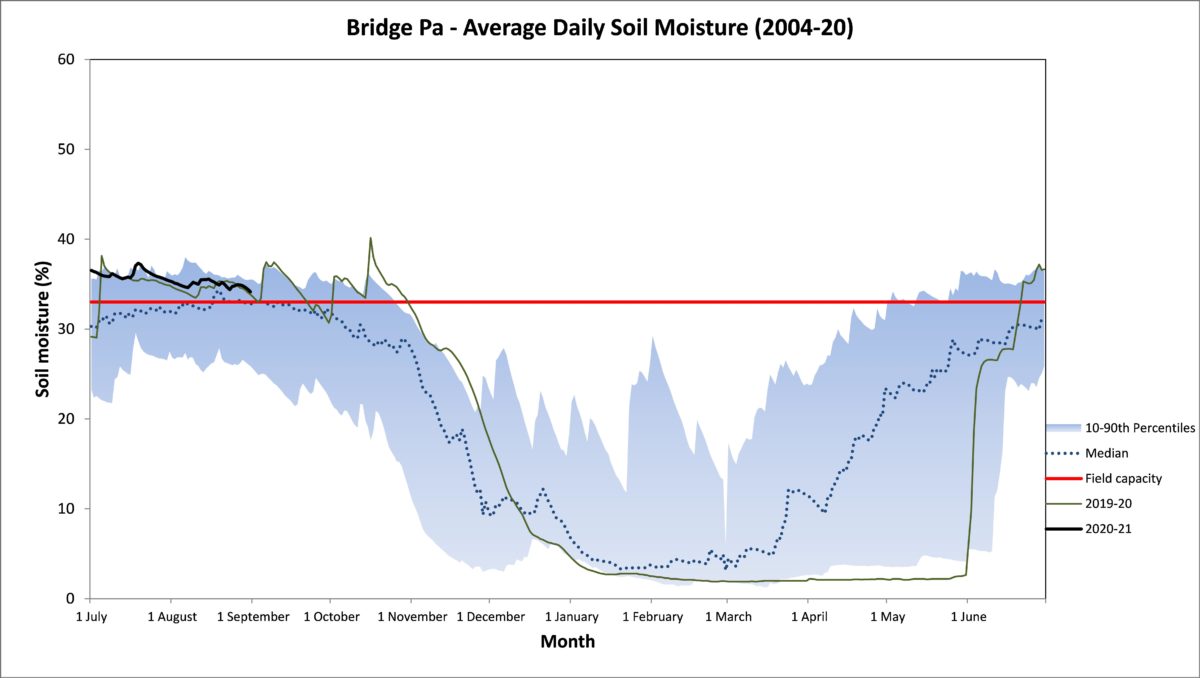
August 2020 Rain Map
John Wilton
Unless you have a specific early market “niche” or requirement for harvest management your main reason for using dormancy breakers is to compress bloom. Early application of dormancy breakers spreads bloom rather than compress bloom. This is bad news for chemical thinning, crop management, particularly at harvest and disease control. If your objective is early harvest lifting rates may improve bloom compaction so overcome some of the lack of bloom compression from an early dormancy application.
Micro-climate also influences dormancy breaker response. In general terms inland valleys cut off from the sea breeze are two weeks earlier for application than coastal sites. Cultivars and tree age differ too.
Mature trees respond to early application of dormancy breakers better than young trees. Again, there is about two weeks difference here too. Some cultivars, Pink Lady® group for instance, do not need dormancy breakers here. It is also doubtful for Scifresh unless the block has a history spread bloom problems.
Try to benchmark your dormancy breaker application against an earlier dormancy breaking deciduous tree. This will tell you if the spring is running early or late so you can adjust timing accordingly. For bloom compression in mature Royal Gala types optimum timing here is around mid-August for bloom compression.
Russet prone varieties e.g. Scired, require later dormancy breaker application, as well as a dormancy breaker that will bring leaf buds out with blossom buds.